
Today is the 35th anniversary of the eruption of Mount St. Helens, a mountain in the Cascade Range, located in southwestern Washington State.
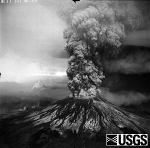
At 8:32:17 a.m. PDT on Sunday, May 18, 1980, an earthquake caused the north face of the mountain to slide away, producing the largest landslide ever recorded that moved at 110 to 155 miles per hour (177 to 249 km/h). The eruption column rose 80,000 feet (24 km; 15 mi) into the atmosphere. Strong winds carried ash east of the volcano at an average speed of about 60 miles per hour (97 km/h). In Spokane, WA, 250 miles away, visibility was reduced to 10 feet (3.0 m) by noon. Noticeable amounts of ash fell in 11 states. Some of the ash drifted around the world in two weeks. The eruption lasted about 9 hours.

The U.S. Geological Survey reports the following data about the 1980 eruption:
- 1,314 feet (400 m): elevation lost
- 2,084 feet (635 m): depth of crater formed
- 0.60 cubic miles (2.5 cubic kilometers; 3.3 billion cubic yards; 165 million large dump trucks): volume of landslide deposit
- 80,000 feet (24,000 m): height of eruption column reached in less than 15 minutes
- 0.26 cubic miles (1.0 cubic kilometers): volume of volcanic ash produced
Destruction caused by the eruption covered 150 square miles:
1. 57 people were killed.
2. More than 11 million animals died, including:
- 1,500 elk
- 5,000 deer
- 12 million salmon fingerlings
3. More than 4 billion board feet of timber, 230 square miles (600 km2) of forest were knocked down, though some lumber was later recovered.
4. Also destroyed:
- 200 houses
- 27 bridges
- 15 miles (24 km) of railways
- 185 miles (298 km) of highway
The number of human lives lost could have been much higher. Because the eruption occurred on a Sunday, more than 300 loggers were not working in the area.
Eruptions since 1980
During the summer of 1980, five more eruptions occurred. Geologists also carefully watched incidents of volcanic activity between 2004 and 2008.
Resources
Dzurisin, D., Driedger, C.L., and Faust, L.M., 2013, Mount St. Helens, 1980 to now—what’s going on?: U.S. Geological Survey Fact Sheet 2013–3014, v. 1.1, 6 p. and videos. (Available at http://pubs.usgs.gov/fs/2013/3014/)
I used the PDF of this fact sheet for much of the information here. The web version includes videos.
Because the May 18, 1980, eruption was preceded by more than two months of earthquakes and steam-venting episodes, people began to doubt that danger was imminent. This four-minute video from History.com condenses the history of the eruption and gives a good idea of how people reacted, both before and after, the eruption. Be sure to notice the remarks of local Mount St. Helens resident Harry R. Truman, who is buried, along with his 16 cats, on the mountain.
Note: Music accompanies this video. You can turn it down or mute it, as you wish. You have been warned.
35 years after Mount St. Helens eruption, nature returns
This CBS News report covers the return of life to the Mount St. Helens area in the 35 years since the eruption. It’s an uplifting story to see after reading about all the devastation.

3 thoughts on “35 Years Ago Today: Mount St. Helens Erupts”
Comments are closed.